Bay Explorer
Southern Cross Station to Brighton Beach, Distance: 16 km
Region: Southern Melbourne
Written up by: U3A Yarra City OYB
Last ridden: 19 February 2021
Cafes | Terrain | Ride Details | Variations | Maps
Overview
What is not to like about riding along the bay? As the weather changes so too does the beauty of the sea, from calm and still in bright sunshine or in mist, to rough and choppy. This ride is always a delight. The ride commences near Southern Cross Station at Clarendon Street/South Wharf outside the Melbourne Exhibition Centre (aka Jeff’s Shed). It follows the bike path alongside the light rail trail to Port Melbourne and then heads east and south along the Bay trail.

Tommy's Story

Brighton Beach Bathing Boxes
As you ride south from the city to Elwood look out for a range of public sculptures, including the sun and planets (scale models spread out over a few kilometres), the Tommy’s Story sculpture (a bronze sculpture of a pair of trousers and shoes on the sea wall, and Angelina Rabbitgirl and Dogman.
Just after you cross over Elwood Canal, there is a wooden beacon on a hill on your left. Ride across the grass and up the path to the top to enjoy some great views of Melbourne.
In Brighton look for the bathing boxes and take in the views across the bay to the You Yangs.
Cafes
There are cafes and toilets at frequent intervals on this route. Favourite cafes include North Point (at the end of North Road behind the Foreshore Playground about 1km after Elwood Beach) and Sandbar (on Middle Park Beach).
Terrain
The ride is along bike paths and is mainly flat.
This ride is more challenging when there is a strong southerly wind. In this case you may prefer to start at Brighton Beach.
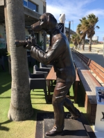
Dogman
Ride Details
Southern Cross Station to Station Pier (3.8km)
Start at Southern Cross Station in Spencer Street.
Walk your bike south across the river to reach Clarendon Street/South Wharf outside the Melbourne Exhibition Centre (Jeff’s shed).
Walk south along the footpath on the west side of Clarendon Street and cross Normanby Road to find the bike path that heads west next to the light rail line. (230m)
Follow the light rail trail until its end just across Waterfront Place from Station Pier. (2.9km)
Station Pier to Brighton Beach Station (12.6km)Cross Waterfront Place at the pedestrian crossing.
Turn left onto the Bay Trail.
Follow the Bay Trail to Pier Road. (3.8km)
Here the trail turns right and follows Pier Road. You will need to ride on Pier Road for a short distance, but there is little traffic on this side road. (750m)
At St Kilda Pier pass through the bollards back onto the off road path.
Follow the Bay Trail until you reach Brighton Beach. Just after the car park to the Green Point Foreshore Reserve, you will ride via a dip to the left of some toilets. Just after this, use the lights to cross the Esplanade at the intersection with South Road, and then cross South Road before making your way to the station. (8.2km)
Variations

Little (Fairy) Penguin at St Kilda.
Side trip
Ride down St Kilda Pier to and around the back of the kiosk to look for Little Penguins (known locally as Fairy Penguins because of their small size) in the rocks of the breakwater.
Vary the ride by replacing the ride down the light rail, in one of the following ways:
following the route in Westgate Park. Just continue straight ahead at Station Pier.
starting at Flinders Street and going past Albert Park Lake as in City to St Kilda Circuit. When you reach the beach, turn left instead of right.
Extend the ride by
riding on to Hampton Station (1.9km) or
riding on to Sandringham Station (3.4km) or
adding all or part of Beaches and Cliffs.
Maps
Melway or Melway Online: Starts at map reference 43 F11
Google: The map starts just south of the Yarra River. Note that it is incorrect at the purple circle. Here do not turn left onto Beach St. Instead continue straight ahead past the tram stop to cross Waterfront Pl at the pedestrian crossing before turning left.
Please click on box with arrow at top left corner to see the map legend.
Please click on box at top right corner to see the map in Google Maps. You must be logged into Google Maps to do this.
